Youtube Video
Overview
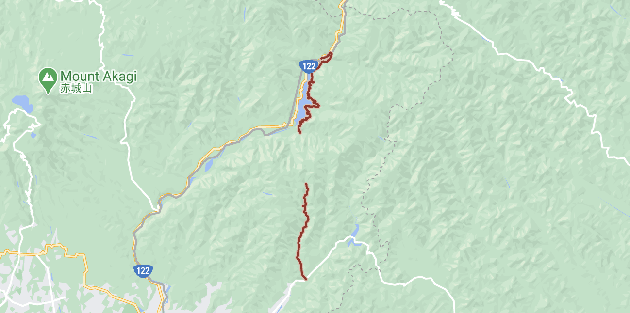
It has been a while since I did a full on exploration ride with gravel, but with covid going on business is slow so I thought I would give Gunma Rt 343 a run to it’s end to see what lies beyond the pavement!
I have ridden to the intersection with the currently under construction Umeda Kodaira Line 梅田〜小平線 and have explored both branches (all yellow and light blue lines below) of it last spring to check the status of the rindo construction. Currently there is still construction now in fall of 2020, but you can pass often on days they are not working or early in the mornings.
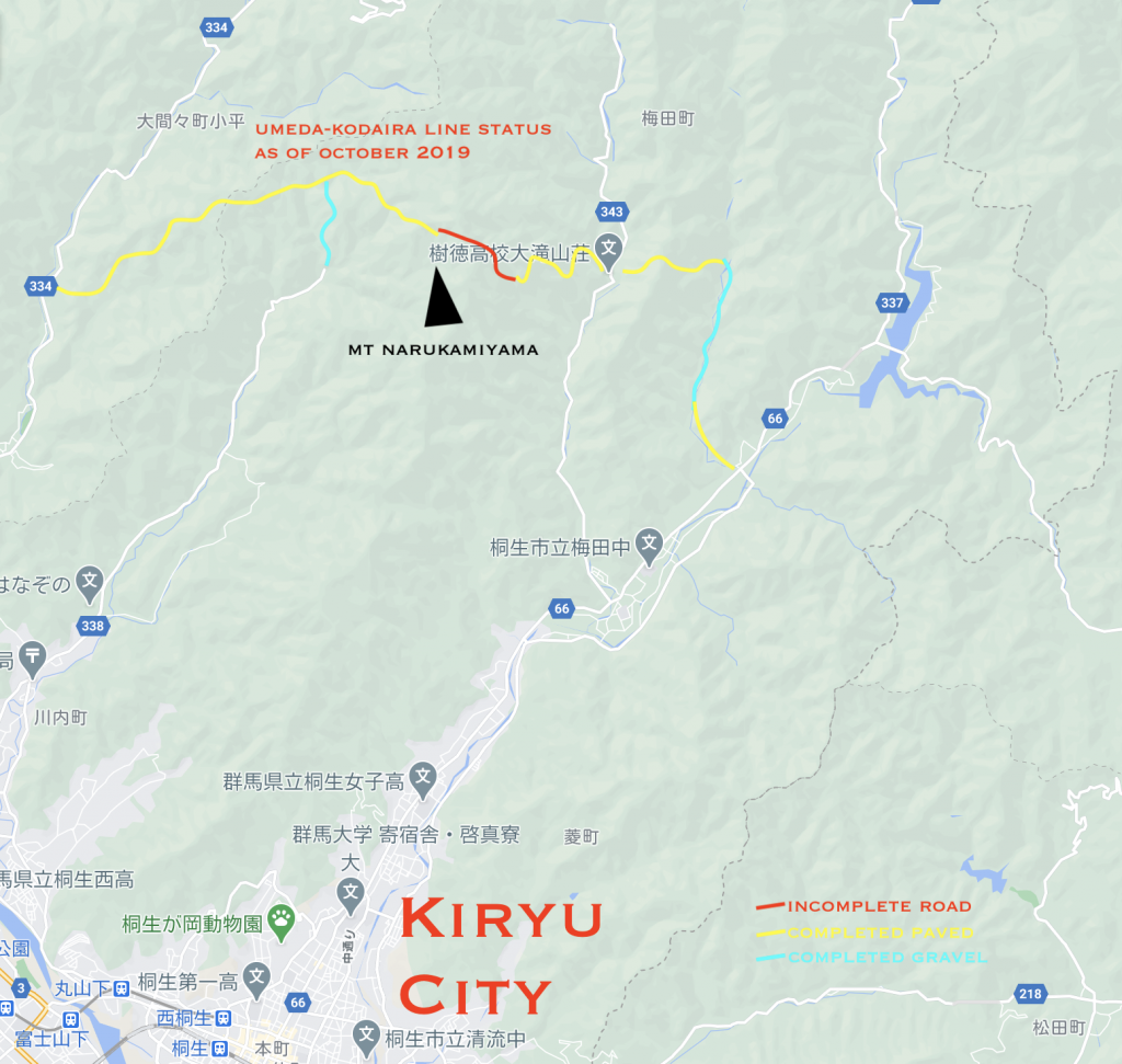
It is unclear if the red area will be completed or when, but there were workers on the 343 side of the road this spring so there is hope that it is going to be completed one day!
Today’s post, however, is about the continuation of rindo 343 north bound. There are many posts in Japanese dating back to the early 2000s of cyclists and motorbike riders trying these roads, but because most of them are over 10 years old I think most of the information is not very useful.
Still, it is fun to read these old ride reports as the can be inspiring, so if you are interested here are some links to the area from past riders and bloggers.
https://gekicyousa.at.webry.info/201903/article_2.html
https://minkara.carview.co.jp/userid/2172672/blog/37009057/
http://www5f.biglobe.ne.jp/~sy-baba/kiroku51.html
I even found this recent youtube video from a motorbike rider who seems to have been told off by the construction workers this spring 😛
「林道」梅田~小平線・オープンゲートの先は現場だった(笑)編 オフ車 CRF250R
Some fun facts I learned about this route 群馬県道343
- The route was thought to be an option for a railroad at one point towards Nikko up the Takazawa River & over the
- The road has two pieces, one on the east side of Lake Kusagi, and the other leaving Kiryu.
- The original name for this line is the Kiryu Sori Line 桐生沢入線. Now the entrance from Kiryu reads 桐生鍋足.
The Plan
After a few hours of scouting different maps on the links above I plotted my course accordingly.
It can be really difficult to determine if there is a road or not within the forests here. Often the tree coverage is so dense you cannot see it from the maps. That said thanks to the wonders of Google 3D mapping technology I was able to see slight lines in the images when viewed in 3D mode.
So, I planned to try the green pass first, and if it proved impassable I would try the yellow options before abandoning back the way I came.
I have ridden the road on the other side of the ridge Gunma Rt 334 called the Omama Kodaira Line 群馬県道334 大間々小平線. This is one of our hidden gems out this way passing at over 1,050m from around 200m on the Kiryu side & ~400m on the Lake Kusagi side. I will have to do another post on it in the future, but suffice to say that the pass is an amazing smooth, virtually car free rindo of epic proportions.
And so with this surefire plan I was off to the woods!
The Ride
Strava Ride File – https://www.strava.com/activities/4201004135
I took off around 9am and began along the Kiryu River cycling path. Then left onto 343 the climbing begins! The first 4.5km is a pretty gentle to undulating climb, but shortly after that the grades kick up quite a bit averaging 12% over the last 1km and ramps up to 20%!

From there you reach the intersection of the Umeda Kodaira Line 梅田小平線. Continue straight up on the rougher road ahead and after one more steep grade the road relents and turns to gravel with a gate.

There were lots of tracks of shoes and tires (from either MTB or motorbikes) so I felt reassured heading past the gated are.
From here a really quite well maintained gravel road continued for around 4.5km. The first half was in the forest along a river with some fun switchbacks and not too steep, maybe 7% avg. But oh man that second half! Once atop the road stayed pretty level and had some fantastic exposures to the valley below.

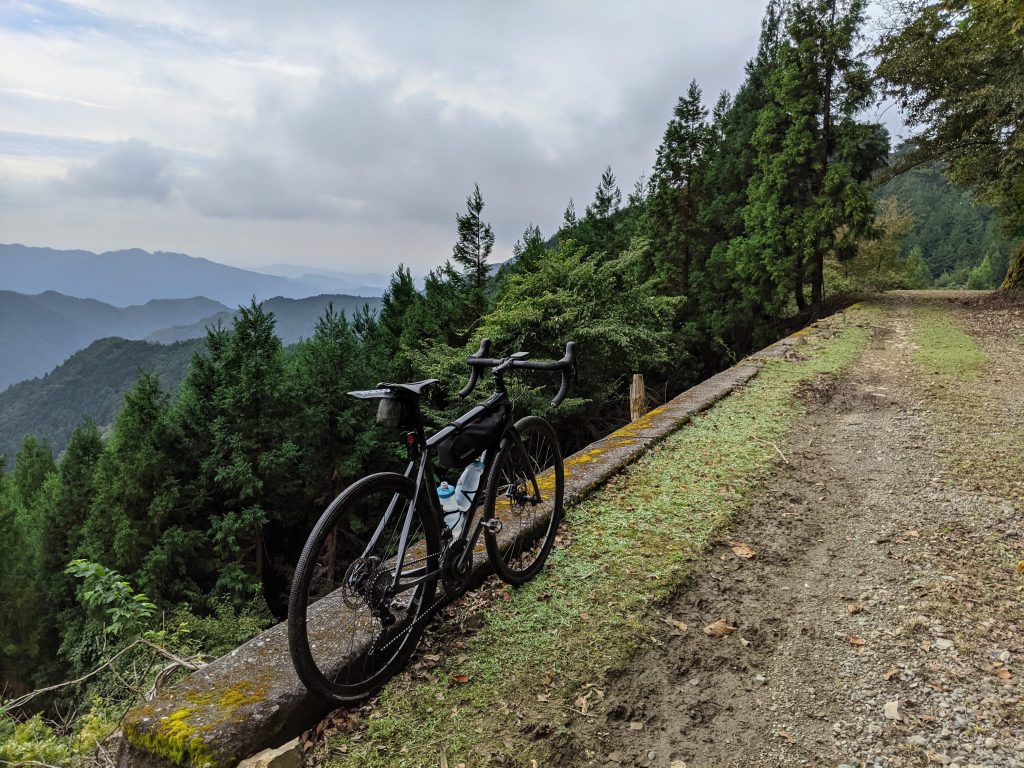
After soaking in the views it was onward and downward? Well, a little down. Just after the exposure was a dip that had me thinking I had reached the top already. But alas, it was just the beginning of my day.
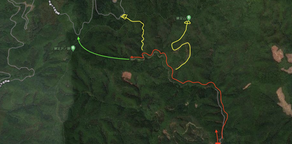
The road came to a rather abrupt end a kilometer or so past this point, but there was what looked like an overgrown road to the left, and a forest logging trail to the right.
I decided to check out the road first, and after a good 30min of hiking up a ridge without the bike found basically a cliff face and decided to head back to the intersection.
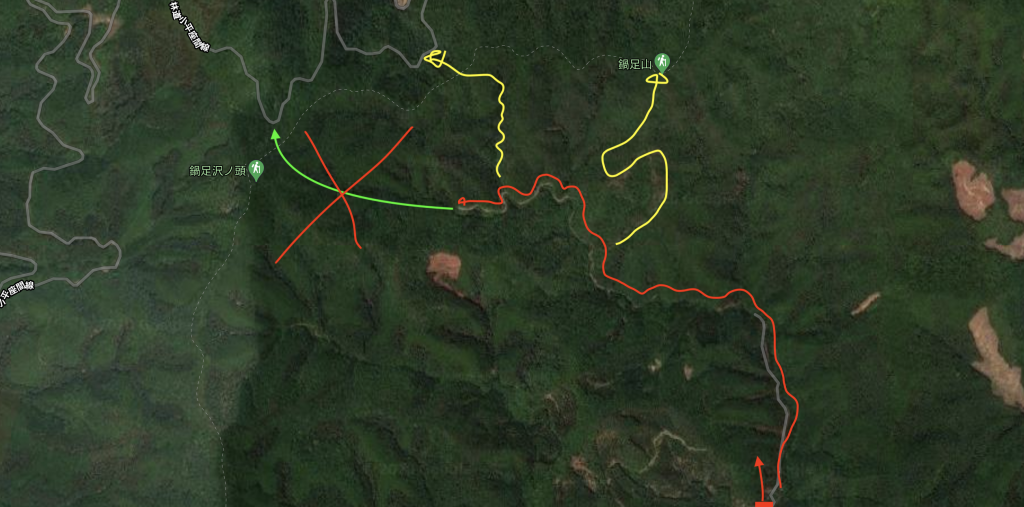
With my cellphone I checked my topography maps and saw that the route I took closely traced Plan A’s route, and back at the intersection decided to take the yellow line nearest for Plan B.
The Scramble
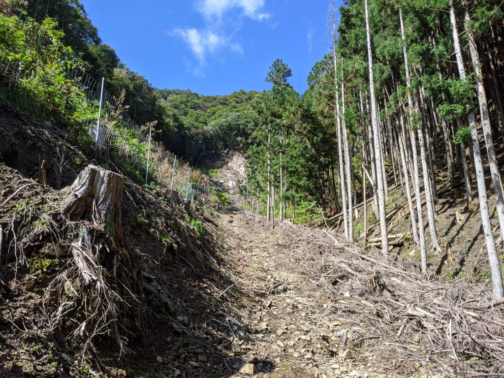
This trail was a typical Japanese logging road. Rough, chunky, and like 25% average grade. Nonetheless, I pushed my bike up as the way forward was at least obvious.
Then I arrived at a gated area with a steep, like stupid steep, trail marked out beside it. After some assessment of the situation and another check on the topography map I decided to start to scale the wall in front of me.
It was not my finest moment. As the loose dirt eroded away from my feet with each step I grabbed the fence with one hand, foot firmly in another link of the fence, and hoisted my 15kg of bike and camera gear with the other. I fell, a lot. And those 50m took some 20min of what I can only really describe as rock climbing with a bike?
If this ever becomes a sport, I will stay far from it.
The Hike
None the less, once atop the ridge I was at around 900m above sea. “Great!”, I thought. The road summits at 1,050m, and the saddle seems to sit around 980m, so this should be a walk in the park.
Well this particular walk was in an overgrown rocky jungle. It turns out I had to follow the ridge up to the top of Mt Nabeashi-no-atama 鍋足ノ頭 at some 1,068m above sea via a ridge line I can only describe as an undulating set of 30m spikes. I counted 6 summits until the last one taking me down to rt 334 群馬県道334.


There were also two time that I got within sight of the road, just some 50m or so away. Alas it was 50m over and 50m down as well.
But, after 2.5 hours of hiking I retouched pavement and was on my merry way back to Kiryu along the thrilling Rt 334!
The Review
On one hand this ride was an epic failure. I spent as much time hiking my bike up and down overgrown brush as I did pedaling it. While on the other the sheer silliness of the adventure seems worth it. In hindsight of course, cuz in the moment it was very much questionable at times.
I loved the ride up to the gravel road on Gunma Rt 343 群馬県道343 and will be going back there soon on a clear day for that view. And, as if I didn’t get enough already, I found another blog from a hiker describing a pass called Zaswa Pass 座沢峠 that seems to be a dirt road off of 343 leading to a single track once over the saddle down into Lake Kusagi. Fun right? What could possibly go wrong…
That will be for another day. For now Gunma Rt 343 群馬県道343 adventure 1 in the book. I think next up I wanna check on the progress of that Umeda Kodaira Line 梅田〜小平線 between Kiryu side Rt 343 and Omama side.
Til next time~
またね〜
Rindo Rob
林道ロブ